Coastal Issues
This page is a summary of Coastal Issues in the Florida Keys, click on the corresponding pages or the links below for a more in depth analysis of specific issues along Florida's coastline.
Geology
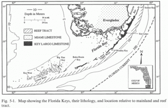
Geology of the Florida Keys
The Geology of the Florida keys greatly influence the coastal issues.
The Florida Keys are categorized based on their geology. The upper Keys are sedimentary in nature and stretch from Virginia Key in the North to Soldier Key as the Southern Boundary. The sedimentary layer exists upon a solid foundation of Key Largo limestone, which were the preaks of a once living coral forest. Extending Southward from Soldier Key, are non sedimentary Keys and are classified as High Coral Keys, Low Coral Keys and Oolite Keys. The geology influences current flow, thus altering sediment transport and pollution and nutrients migration.
To explore more about the Geology of the Florida Keys click HERE.
Currents
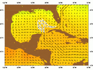
Current velocity vectors in the Caribbean basin
Florida's geology leads to unique currents:
The Loop Current is an ocean current that transports warm Caribbean water through the Yucatan Channel between Cuba and Mexico. The current flows northward into the Gulf of Mexico, then loops southeastward through the Florida Keys (where it is called the Florida Current), and into the Bahamas. Here, the waters of the Loop Current flow northward along the U.S. coast and become the Gulf Stream. With current speeds of about 0.8 m/s, the Loop Current is one of the fastest currents in the Atlantic Ocean. The current is about 200-300 km (125-190 miles) wide, and 800 meters (2600 feet) deep, and is present in the Gulf of Mexico about 95% of the time. During summer and fall, the Loop Current provides a deep (80-150 meter) layer of vary warm water that can provide a huge energy source for any lucky hurricanes that might cross over.
To explore more about the current and its impact on the coastal environment click HERE.
Erosion
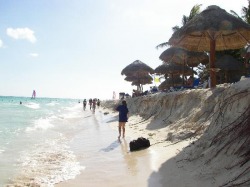
Eroded Beach
The Unique Currents in Florida attribute to critically Eroded beaches.
The Middle Keys region spans from Tavernier Creek to Pigeon Key and currently has 3.5 miles of critically eroded beaches along its shoreline. The hardest hit of all the sub-regions in the Keys is the span from Pigeon Key to Key West, Florida. This region alone has 6.7 miles of critically eroded beaches (Bureau, 2008). Beach erosion is attributed to high velocity current flow and severe weather
To explore more about beach erosion click HERE.
Coral Reef Degradation
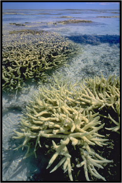
Bleached Coral
Combination of Coastal issues have contributed to the degradation of the Coral Reefs.
To the east of the Florida Keys lies the only living coral reef in the continental United States. It is located between four and seven miles offshore, running parallel to the Keys from Key Largo to the Dry Tortugas. This living marine marvel, rising as high as a few feet below the surface of the water and descending to depths near the Gulf Stream, protects the Keys from the waves of the pounding Atlantic surf and hence from the development of sand beaches, a great surprise to many first-time visitors.
To explore more about the Issues surrounding the Coral Reefs click HERE.
