Florida's Current
Currents along the Florida Keys
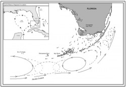
The Florida current can be considered the "official" beginning of the Gulf Stream System. It is defined as that section of the system which stretches from the Florida Straits up to Cape Hatteras. The Florida Current was first reported by the Spanish explorer Ponce de Leon in 1513 when he discovered Florida. The Florida Current receives its water from two main sources, the Loop Current and the Antilles Current. The Loop current is the most significant of these sources and can be considered the upstream extension of the Gulf Stream System.
Loop Current
Loop Current
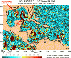
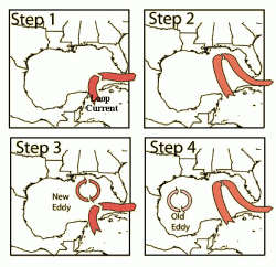
The Loop Current is an ocean current that transports warm Caribbean water through the Yucatan Channel between Cuba and Mexico. The current flows northward into the Gulf of Mexico, then loops southeastward through the Florida Keys (where it is called the Florida Current), and into the Bahamas. Here, the waters of the Loop Current flow northward along the U.S. coast and become the Gulf Stream. With current speeds of about 0.8 m/s, the Loop Current is one of the fastest currents in the Atlantic Ocean. The current is about 200-300 km (125-190 miles) wide, and 800 meters (2600 feet) deep, and is present in the Gulf of Mexico about 95% of the time. During summer and fall, the Loop Current provides a deep (80-150 meter) layer of vary warm water that can provide a huge energy source for hurricanes.
Current Variation
The Florida Current has demonstrated that it is subject to both seasonal and interannual variability. These changes are significant and can amount to large difference between high and low water and sediment transport values along the eastern Florida coast.
The transport of the Florida current has been shown to increase substantially between the Straits of Florida and Cape Hatteras. It has been found that transport increases 3 fold from the Straits of Florida to Cape Hatteras .
Determined from current meter data in the Florida Current, have wavelengths of 340 km and 170 km, periods of 12 days and five days, and propagate at 28 km/d and 36 km/d, respectively. The amplitude increases outside of the constraint of the Straits of Florida. The eddies that are generate serve as the principal form of mesoscale variability along the path of the Florida Current between Cape Canaveral, Florida and Cape Hatteras, North Carolina. The Florida Current is deflected offshore near 32°N and it's eddy variability decreases downstream of this deflection. The deflection of the Florida Current is caused by the presence of a topographic irregularity known as the Charleston Bump near 31°N. This deflection in the path of the current has been shown to be bimodal in character with the Florida Current assuming either a weakly or strongly deflected state. The Florida current can remain in the strongly deflected mode for at least several months. Historical records have shown that monthly variability within the Florida current can be as high as the seasonal variability There are also short term variations with periods of 2-20 days. These fluctuations are correlated to local winds and are much stronger in summer than in winter.
